
דוד טרטקובר — יםהגדול
חמישי, 07.06.18 | שעה 20:00
אודות התערוכה
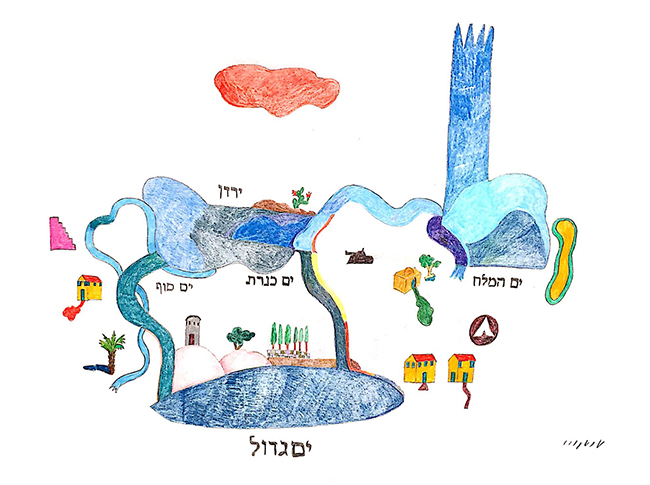
סדרת הציורים ים הגדול של האמן דוד טרטקובר מבוססת על מפה סכמתית מתחילת המאה ה-19, המיוחסת לגאון מווילנה וצוירה על ידי תלמידיו.
המפה המקורית שנכתבה בעברית, נקראת “חלוקת ארץ ישראל לגבולותיה” ונועדה לסמן את נחלות שבטי ישראל על פי חזונו של הגר”א שמעולם לא הגיע לארץ ישראל. המקרא, שהוא ההשראה המילולית למפתו של הגר”א, מבחין בין שני סוגי גבולות לארץ ישראל: גבולות ההבטחה כפי שנמסרו לאברהם אבינו בברית בין הבתרים, והגבולות שעל פיהם צווה עם ישראל לכבוש אותה.
בסגנון תם, פשוט וישיר; בצבעי מים, דיו ועלי זהב על נייר, שחזר הגר”א את ארץ ישראל כך שהנחלים, הנהרות, הימים וההרים היוו גבולות טבעיים לשבטים, הבתים צוירו בסגנון אירופאי, הערים הגדולות כאגרופים והערים הקטנות כמגרות. טרטקובר לוקח מחזונו של הגר”א את התום והישירות, את כיוון המפה מזרחה, את תפיסתה הגיאוגרפית המיתית, ומערב אותם עם דימויים המעסיקים אותו תדיר. צבר, בית עם רעפים אדומים, שביל ושדרת ברושים, טנק, עץ דקל ועב אדומה המרחפת על פני השמים, מסמנים מחדש את מפת הגבולות החדשה של עם ישראל שכבר לא מחולק לשבטים. נאמן לשיבוש, ים כנרת וים סוף מתאחדים, מים המלח מזדקר ארמון רב תפארת, הירדן לא נשפך לכנרת ונהר פרת נשפך ליםהגדול.
היםהגדול, הוא הים התיכון, כביר וכחול, בתחתית הפריים, הוא הגבול היחיד המדויק המשותף למקור, להשראה ולמציאות, ומכאן שמה של התערוכה. מודע לפלפולים ההיסטוריים אודות גבולותיה הלא מסומנים של ארץ ישראל, מתקופת המשנה ועד ימינו, וכלאחר ייאוש מחוסר התוחלת לגיבוש גבולות אנושיים למדינת ישראל, מאמץ טרטקובר את ההתיילדות והתום בצבעי עפרון על גבי נייר, מצייר פנטזיה פסטורלית כל כך לא מתקבלת על הדעת, שהיא נוטלת את העוקץ מוויכוח פוליטי-משיחי וממקדת את תשומת הלב ביםהגדול המשמש עד יחיד ויציב לתהפוכות, לזמנים, לזיכרונות, למצב הרוח ולבִּיטוּיָם האמנותי.
אוצרת
חנה קומן
נעילת התערוכה
30.06.18
David Tartakover — BigSea
Thursday 07.06.18 | at 20:00
Tartakover’s BigSea series of paintings is based on a schematic map from early 19th century attributed to the Vilna Gaon, painted by his pupils.
The original map written in Hebrew, is titled “Eretz Israel Border Division”, and is aimed to mark the estates of the twelve tribes according to the vision of the Vilna Gaon, who never actually saw it. The bible, which is the verbal inspiration to the Vilna Gaon’s map, distinguishes between two types of borders for Eretz Israel: the borders as promised to Abraham in the Covenant of the pieces, and the borders by which Israel was commanded to occupy it.
In a naïve, simple and direct style, in aquarelle, ink and gold leaves on paper, the Vilna Gaon reconstructed Eretz Israel so that the streams, rivers, lakes and mountains formed natural borders for the tribes, the houses were drawn in European style, the big towns as fists and the small towns as drawers. Tartakover adopts from the Vilna Gaon’s vision the innocence and directness, the orientation towards the East, the mythical geographic perception, and blends it with imagery incessantly preoccupying him. Sabra, a house with red tiles, a path and a row of cypresses, a tank, a palm tree and a ruby cloud hovering over the sky, remark the people of Israel’s new border map, no longer divided into tribes. Faithful to the deformation, the Sea of Galilee and the Red Sea merge, a formidable castle emerges from the Dead Sea; the Jordan River doesn’t flow into the Sea of Galilee and the Euphrates flows into the BigSea.
The BigSea, the Mediterranean, immense and blue at the bottom of the frame, is the only accurate border shared by the original, the inspiration and reality, hence the exhibition’s name. Aware of the obsessive Talmudic debate over Eretz Israel’s unmarke d borders, desperate from the lack of vision regarding the attainment of humane borders for the state of Israel, Tartakover adopts the childlike naiveté in pencil colors over paper, painting a pastoral fantasy, so implausible that it removes the sting from the messianic-political debate and focusing the attention on the BigSea serving as only witness to the upheavals, times, memories, moods and their artistic expression.